Saturday, August 28, 2010

Malaysia


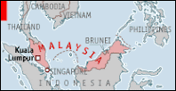
The modern nation of Malaysia consists of the southern half of the Malay Peninsula and the states of Sarawak and Sabah on the northern coast of the island of Borneo. Each of the three components were British colonies, with Malaysia obtaining its independence in 1957. Sabah, Sarawak, and Singapore obtained their independence six years later and joined with Malaysia to create the Federation of Malaysia. At this time, the Sultanate of Brunei (also on Borneo) declined the invitation to join the federation. Singapore was expelled from the federation in 1965.

The present state of Malaysia covers 125,584 square miles, comparable to the area of the state of New Mexico. In 2008, it had a population of approximately 25.3 million. The country’s people are ethnically diverse, with Malays constituting 50.8 percent, Chinese 23.8 percent, and Indians 7.1 percent. About 10 percent of the people, primarily residing in Sarawak, are indigenous people who have inhabited the land since prehistoric times. Religiously, the country is about 69 percent Muslim, with almost all Malays professing Sunni Islam. Most of Malaysia’s Muslims, including immigrants from Indonesia, follow the shafii legal school, which was introduced in the 15th century. Islam is also the religion of many of the Indo-Pakistani community, and about one-third of the indigenous people of Sarawak. Sufism has broad popularity in the country, and there is also a sizeable community of Shii Muslims. Buddhism is professed by about 20 percent of the people, overwhelmingly Chinese. Most of the Indians are Hindus from southern india. Christianity has made an impact primarily among the non-Malay half of the population, and now claims about 9 percent of the population.

From the first century c.e., Malaysia experienced migrations from both China and India and it became the home of kingdoms with Hindu and Buddhist roots. In the 15th century, following the opening of the port of Malacca on the peninsula’s west coast, the first conversions to Islam were reported. Through the next century, Islam gradually replaced Buddhism as the dominant faith on the peninsula, and a set of states was established, each headed by a sultan. Islam’s initial converts included some among the aristocratic class on the peninsula. It spread among this class over several centuries, often through marriage alliances.

Beginning in the 16th century, a variety of European colonial powers moved into the region. In 1511 the Portuguese seized Malacca. In the next century, the Dutch, in alliance with the sultan of Jahor, drove the Portuguese out. At the end of the 18th century, the British established their trading colony on the northern shore of Borneo and, in 1819, purchased Singapore from the sultan of Jahore, which they managed as an outpost to secure passage through the Straits of Malacca and the Singapore Straits. Shortly thereafter the British concluded a treaty with the Dutch guaranteeing the latter’s hegemony in the East Indies (now indonesia).

Through the 19th century the British controlled the ports of Penang, Malacca, and Singapore into which they encouraged immigration from China and India to provide cheap labor for the tin mines and rubber plantations. Beginning in 1870 the British encouraged the formation of protectorates over the several sultanates on the Malaysian Peninsula and later in the northern half of Borneo (including Brunei). British rule was not welcomed by many Malays, including Muslim religious leaders who regarded the British as kafirs (disbelievers). The Japanese invaded and occupied the region during World War II. After the war continuation of British colonial rule became increasingly untenable, which led to independence in stages through the 1950s and 1960s. With independence in 1957, Islam was named the state religion. The National Mosque (Masjid Negara), completed in 1965, serves as a symbol of Islam, the country’s dominant faith.

Malaysia is a constitutional monarchy consisting of 13 states and one federal territory. Each state has a parliament and a chief minister. The chief ministers of nine of the states are hereditary rulers known as sultans who also oversee the Islamic affairs of their respective states. Every five years there is an election and one of them is selected as monarch. There are four states (Penang, Malacca, Sabah, and Sarawak) that are governed by chief ministers appointed by the government. There is also a national parliament elected by the people with the prime minister the highest elected official. Sarawak and Sabah have no designated head of Islam, but the king oversees the religious affairs of Penang and Malacca.

In 1965 a council for Islamic affairs was created. Operating out of the prime minister’s office, it coordinates the efforts of the state councils, which advise the sultan on religious matters. The state and national legislatures have some power in legislating for the Muslim community. The constitution of Malaysia contains a provision affirming freedom of religion. At the same time, Islam is the official state religion. The practice of forms of Islam other than Sunni Islam is restricted significantly. Hari Raya Puasa (the end of the fasting season of ramadan), Hari Raya Qurban (the Feast of the Sacrifice at the end of the haJJ pilgrimage), and the Prophet Muhammad’s birthday (mawlid) have been designated official national holidays. The issue of Muslims wishing to convert to another faith, primarily Buddhism or Christianity, has been a sensitive one in Malaysia. Ethnic Malays must overcome particularly difficult obstacles to leave the Islamic faith for another religion. In 2001 a High Court judge ruled that the constitution defined an ethnic Malay as “a person who professes the religion of Islam.” There are few obstacles to anyone who wishes to convert from Buddhism or Christianity to Islam.

During the last decades of the 20th century and the early 21st century Malaysia has been dominated by the United Malays National Organization (UMNO), seen as the more moderate political party of the Muslim community. It is opposed by the Parti-Islam se-Malaysia (PAS), a more conservative group that has as its stated goal the transformation of Malaysia into an Islamic state that would adhere to sharia law, including its punishments, such as amputation and stoning.


~ J. Gordon Melton

Malay Peninsula: Part II


The above sources for the location and political history of Langkasuka also supply some information regarding the social and economic life of ancient Langkasuka. One source tells us that the men and women of the country usually did not cover the upper part of their body, their hair hung loose on their backs and they wore cotton sarongs. The King and high officials covered their shoulders with cloth, wore golden cords as girdles and golden ear-rings. The women wrapped themselves in cotton cloth and wore jeweled belts. Another writing in 1226 states that the ruler wore silk and used no footwear. The inhabitants of the country trimmed their hair and wore silk. A fourteenth-century Chinese trader records that the people were honest; men and women braided their hair into chignons and wore cotton cloth. They had white teeth. They maintained strong family ties and showed much respect and consideration to their elders. They boiled sea-water to make salt and fermented rice to make wine. Quoting the seventh-century records, the kingdom was surrounded by walls with double gates, towers and pavilions. The King, shaded by a white parasol, rode on an elephant and was accompanied by banners, fly whisks, flags and drums. He was guarded by soldiers. I-tsing informs us that the King of the country received the foreign guests with courtesy and respect.

The various commercial products of Langkasuka are enumerated as follows in the various works: aromatic woods—aloes wood (eagle wood or gharu wood), laka wood, barus champor—ivory, and rhinoceros horns. The Chinese exchanged them for textiles and porcelain. Chau Ju-kua records:

Foreign merchants trade here in wine, rice, skeins of Ho-ch’ih (after the name of the district) silk, porcelain vessels, and such-like goods. Each of them first weighs his goods against gold and silver and afterwards engages in barter…

There was easy access from Patani (which no doubt was Langkasuka’s main town and port throughout her history) to the gold mines of Kelantan, Terengganu and Pahang. Gold could also be panned out from the Patani River. With plenty to offer in the way of commercial products, and being itself situated strategically and with a harbor safe in most seasons and available for both monsoons, Patani was a favourite stopping place for the early traders.

Kedah was by far the most important Kingdom and port of ancient Malaya from the third century A.D. It continued to enjoy that position until the rise of Malacca in the fifteenth century A.D. The Ptolemaic geography of the second century A.D. makes no mention of Kedah, although it gives us the names of two ports in the Golden Chersonese, Takkola (Trang) in the north and Sabana (Klang) in the south. It appears, however, that soon after this the traders realized the greater advantages of the hitherto insignificant harbor of Kedah, for from the third century onwards it figures prominently first in Indian and then in Chinese and Arab sources.

The famous Tamil poem of the second and third century A.D. speaks of regular trade between Kalagam (Kedah ?) and the ancient southern port of India.

Kedah appears again as Kidaram, Kadaram, and Kataha in the Chola inscriptions of the eleventh century. The importance of Kedah at this time could not be better highlighted:

First an attack on the capital of Sri Vijaya in which the King was taken prisoner, followed by the occupation of two important ports of the East Coast of Sumatra; then the conquest of the Malay Peninsula, and finally Atjeh (Lamuri) and the Nicobars on the way home; and all this summed up in the fall of Kataha.

In the Chinese works, Kedah first figures in the writings of the Buddhist pilgrim I-tsing who refers to it as Chieh-ch’a. He visited the Kingdom himself in A.D. 671:

Tamralipti was the place where we embark when returning to China and sailing from there two months in the south-east direction we come to Chieh-ch’a, by which time a ship from Sri Vijaya will have arrived, generally in the 1st or 2nd moon; we stay in Chieh-ch’a till winter, then start on board ship for the south and come after a month to Mo-lo-yu, which has now become Sri Vijaya, arriving generally in the 1st or 2nd moon; we stay there till the middle of summer and sail to the north reaching Kwangtung in about a month, by which time the first half of the year will have passed.

The course of the voyage described by I-tsing makes it clear that by Chieh-ch’a he meant the entrepot of Kedah on the west coast of Malaya.

The consensus of opinion also identifies Ko-lo with Kedah, the Chieh-ch’a of I-tsing (which, however, he mentions as a separate island) and Kalah of the Arabs. Chia-tan clearly places it on the west coast of Malaya.

As for Arab evidence, the Muslim geographers place Kalah between India and China. According to Ya’qubi (9th century A.D.), after the sea of Harkand, which contained Sirandib (Ceylon), lay the sea of Kalah-bar, then the sea of Salahit (Selat, seas south of Singapore). Sulayman (9th century A.D.) explains that bar designates both a kingdom and a coast. Kalah-bar, he says, is a dependency of Zabaj, i.e. Sri Vijaya. At Kalah-bar the ships got well-water which is preferable to spring- or rain-water. The distance between Kulam (Quilon on the Malabar coast) and Kalah-bar was one month’s sail.

Mas’udi (10th century A.D.) records that there were mines of gold and silver in the neigbourhood of Kalah and Sribuza. Several authors state that Kalah had aromatic woods, tin mines, ivory and bamboo.

The cumulative result of all evidence places Kedah on the west coast of Malaya. It does not, however, help us to fix its exact limits, which in any case must have varied to some extent during the course of its long history. From the archaeological finds, it is clear that the earliest settlement was along the River Bujang, a tributary of the River Merbok, which provided excellent anchorage for the ships. The Kedah River then, as now, was a shallow-mouthed estuary exposed to the south-west monsoon. The Kedah Peak (Gunung Jerai) which “could be seen thirty miles out at sea” served as a landmark for sailors.

In addition to having a good harbor, Kedah had a fertile land that provided food for its vast population. There was also access to Ligor on the east coast, although this short cut to avoid a sea journey was not the greatest attraction for traders, who could have used an even shorter route by landing at Takua Pa farther north. Kedah’s River Muda, connected with the Merbok, provided a most valuable means of communication down which were carried most of the Kingdom’s exports. Kedah was famous for its tin, if we identify the Kalah of the Arabs with Kedah, “… a tin-mine there was such as existed nowhere else in the world…from which Kala’I swords were forged and they were true Indian swords”. “No other kind (of swords) in the whole world are better than those of this Kala’i”. Many Arab writers all speak of the good tin that Kedah produced. Bamboo “exported all over the world” is also often mentioned as growing in Kalah. Kedah was also the centre of the trade in aloes, champor, sandal, ebony, brazil-wood, logwood, ivory and spices of all kinds.

Some description of the city and its people is obtained from Chinese and Arab sources. The New T’ang History tells us that the city walls were built of stone, while pavilions, the palace and other buildings were thatched with straw. The Kingdom was divided into twenty-four districts. It supplied a large army consisting of infantry and an elephant corps. The weapons of war were bows, arrows, swords and lances; an armour of leather was used. Silver was in circulation and was the mode of paying taxes. Cows were the favourite domestic animal, while ponies were also reared. Cotton was used for garments. Only high officials were allowed to tie up their hair and wrap scarves round their heads. The King’s name was Mi-si-po-ra, his family name Sri-po-ra. The Arab chroniclers described Kalah as:

very large, surrounded by big walls with numerous gardens and abundant streams of water….Around Kalah there was a succession of towns, small market towns and gatherings of houses. It is a rendezvous for the Brahmana, who are the sages of India.

Wednesday, August 25, 2010

Malay Peninsula: The Ancient States (Part. I)


In the words of Sir Roland Braddell, “The earliest periods in the ancient history of the Malay Peninsula and the Straits of Malacca can only be visualized as a part of the general history of South-Eastern Asia and so of Greater India.”

Ancient Malaya should be spoken of in terms of the Malay Peninsula, a geographical entity in contrast with modern Malaya, a political entity. Like other countries her history is closely connected with that of her neighbours, Thailand in the north and Indonesia in the South.

The place-names such as Tambralinga, Kataha, Takkola etc are all to be located in the north, important for their harbours, connected by suitable routes with the hinterland of Malaya and serving as convenient links between India and China. The north was thus the more advanced region of Malaya, the development of the south being eclipsed by Sumatra, on which the traders concentrated because of her gold and her good harbours that served as convenient halting points before proceeding farther east or west. The architectural and sculptural remains of ancient Malaya are therefore concentrated in the north.

Earliest Chinese sources also bear testimony to the greater development of northern Malaya. Funan, founded in Indo-China in the first century A.D., was the earliest Hinduised empire of South-East Asia. The Liang Shu of the seventh century A.D. informs that in the third century her powerful king Fan Che Man “crossing right over the South China Sea” attacked more than ten kingdoms including Ch’u-tu-k’un (Tu-k’un of other texts ?), Chiu-chih and Tien-sun (Tun-hsun). Then he attacked the kingdom of Chin-lin (on the northern shores of the Gulf of Siam). The names of three of the ten kingdoms may be located on the Malay Peninsula. The tenth-century compendium the T’ai p’ing yu lan states that (Chu ?) Tu-k’un, Chu-Li (Chiu-chih ?), Pien-tou and Pi-sung were situated across the Gulf of Siam. Among the inhabitants were many with white complexions. These four places too were then on the Malay Peninsula, though their exact locations are a matter of conjecture. Chu-Li (Ptolemy’s Kole) may have been on the estuary of the Kuantan River on Malaya’s east-coast.

Of greatest importance to the Malayan historian is the mention of Tien-sun or Tun-hsun in the Chinese sources. Tun-hsun had five kings, all vassals of Funan. On the east the kingdom was in communication with Tong-king, on the west with India (T’ien-chu) and Parthia. All countries came to Tun-hsun for purposes of trade. At this mart (Tun-hsun) East and West met together so that daily there were more than 10,000 people. Precious goods and rare merchandise—there was nothing which was not there. The place was famous for a “wine tree”.

Some source indicates that Tun-hsun was originally an independent kingdom but Fan-Man (Fan Che Man) subdued it. The king of Tun-hsun, a dependency of Funan, was called K’un-lun. In the country there were five hundred families of hu (merchants ?) from India, two hundred fo-t’u (Buddhists ?) and more than a thousand Indian Brahmans. The people of Tun-hsun practiced the doctrine of the Brahmans and gave them their daughters in marriage so that the Brahmans settled there. The kingdom could be situated nowhere else but on the Malay Peninsula. The source indicates that Tun-hsun was a large kingdom and the fact that it was in contact with both India and Tongking would seem to imply that it stretched from coast to coast.

The information pertaining to Tun-hsun, a confederation of five units, testifies to the fact that political organization had developed considerably in Ancient Malaya in the early centuries of the Christian era. Tun-hsun’s trans-peninsular trade with a busy mart presupposes the existence of some legal and economic organization also.

Tun-hsun probably contained some of the states especially those of very early origin. P’an-p’an may be one such state and probably passed under the control of Funan when the latter annexed Tun-hsun and other kingdoms. P’an-p’an “lies to the south-west of Lin-I (Champa) in a corner of the sea. To the north it is parted from Lin-I by a small sea (Gulf of Siam). The country is conterminous with Lang-ya-hsiu (Langkasuka).” “the state of Tuo-ho-lo (Dvaravati) is bounded in the south by P’an-p’an”. South-east of P’an-p’an was Ko-Lo, also called Ko-lo-fu-sha-lo. The latter is placed “in the region of Kedah or of Kra”. The scholar says that P’an-p’an was situated in the Malay Peninsula, on a coastal place on the Gulf of Siam.

Langkasuka is another ancient kingdom of Malaya which figures several times in the Chinese annals and is also mentioned in Indian, Arab, Javanese, Malay and possibly European records. Langkasuka sent embassies to China in A.D. 515, 523, 531 and 568. The first envoys from Lang-ya-hsiu stated that, according to the tradition of their kingdom, it had been founded four hundred years before. If the statement be correct, the beginnings of Langkasuka may be traced back to early second century A.D.

I-tsing, who left his country for India by sea in A.D. 671-2, gives us the itinerary of some of the pilgrims who used Langkasuka as a halting place on their way to India. “Three pilgrims sailed from a small port near Canton passed Funan and reached the country of Lang-chia. The king of Lang-chia-shu treated them well”. Both the name forms stand for Langkasuka.

Cheng Ho (Zheng He), the eunuch admiral, made seven voyages to the West between 1403 and 1433. His collection map depicts the north-east coast of Malaya, Lang-his-chia (Langkasuka) is placed to the south of Singora. Its southern boundary appears to be at the Patani River.

An equally late Arab work (A.D. 1511) places Langkasuka between Kelantan and Singora in the vicinity of Patani.

The Tanjore temple prasati recording the exploits of Rajendra Chola I who invaded Sri Vijaya, also appears to place Langkasuka (Ilangasokam) somewhere in the north of the peninsula, since it groups it with Tambralinga and Takkola. Three other names, however, occur in between, one of which is possibly Panduranga in Indo-China.

The Javanese work, Nagarakritagama, composed in A.D. 1365, lists the Malay Peninsula states as subject to Majapahit in two groups. Langkasuka is grouped with the other east coast states like Kelantan and Terengganu, although also with Saimwang (Johore ?) and Hujang Medini.

The Kedah Annals stand alone in their claim that Langkasuka was a west coast state. It appears that a late annalist was giving written form to current legends and oral history. A fortress with a palace and hall built by Raja Marong Mahawangsa in Kedah is called Langkasuka. It is stated that the king’s son mounted an elephant and with his party set off towards the rising sun [east]. After crossing a vast forest they came to a plain. The king’s son crossed several hills and mountains. When he had almost reached the sea he came upon a great river flowing into the sea. On that plain he stopped. The princess consort said, “Go back to Kedah, to my royal father, and tell him that this is the country called Patani”. The memory of the ancient state of Langkasuka that lasted for a millennien and a half persists in Malay folk-lore. The Patani peasantry remember it as the spirit land of Lakwan Suka, while the Kedah Malays believe that Alang-ka-suka was ruled over by the fairy princess Sadong who never married. A rivulet flowing into the upper Perak was known as Langkasuka until the beginning of this centrury and is shown as such on a manuscript map in the Taiping Museum in Perak.

The cumulative result of the above evidence, except that provided by the Kedah Annals, places Langkasuka on the east coast of the Malay Peninsula, south of Ligor. Its extent during the early period seems to have been larger that it was perhaps in the latter part of its existence, when its northern boundary seems to have shrunk. Patani appears to have occupied the position of its most important town and port, especially in the latter part of Langkasuka’s history.

The political history of Langkasuka may be reconstructed somewhat as follows. Founded early in the second century A.D. it almost certainly passed under the control of Funan when Fan Che Man made his southern conquests. Later, when unsettled conditions prevailed in Funan, Langkasuka restored its fortunes.

Sunday, August 22, 2010

Ancient Malaya


Introduction

After many years of decline these cultures are once more changing and developing, and it is therefore most important that the varied peoples of South-East Asia should take stock of their past, and understand why and how their civilization has taken its present form.

Until recently little attention has been given to Malaya’s history before the coming of the Portuguese. A concession has sometimes been made to include in courses of instruction the century of Malacca’s rule before the arrival of the Portuguese. The rich millennium and a half of Malaya’s historical past, beginning around the commencement of the Christian era and lasting until the spread of Islam in this country has often been relegated to the sphere of mythology.

A cursory examination of the present cultural pattern of Malaya leads to the awareness of very deep roots in the past. But the bulk of learned contributions lie scattered in the pages of the various journals and periodicals.

The study of early Malay history requires the ability to handle archeological data as well as the primary sources in Sanskrit, Tamil, Chinese, Arab, Malay and Portuguese. The need for further archeological research on the peninsula cannot be overstressed. There is no doubt that many old doubts will be solved and new vistas of knowledge opened if the spade is handled in this country under the guidance of trained archaeologists.


The Land and Its People

In the words of Sir G.Elliot smith, Malaya was the “great jumping off place of Asia and cultural exchange”.

In remote times the peninsula of Malaya was continuous with Borneo, Sumatra and Java, the whole land mass forming the southernmost extension of the continent of Asia. Celebes, New Guinea and the neighbouring islands were, on the other hand, joined to Australia. There was always a break between Borneo and Celebes and perhaps also between Lombok and Bali. The sea between the archaic continents of Asia and Australia has been found to be very deep, even though the distance at some places, as between Bali and Lombok, is only about fifteen miles.The geologists informed that the area covered by the Java Sea was perhaps the first to sink as a result of volcanic activity. Later Borneo and afterwards Sumatra became detached and since then many other elevations and depressions have occurred.

Today, the peninsula of Malaya projects from the Asian mainland far into the ocean, dividing the Indian Ocean from the China Sea. Modern Malaya comprises the lower half of the peninsula, the narrow northern part being the territory of Thailand. From the viewpoint of ancient history, however, it will be more accurate to think in terms of the peninsula of Malaya—a geographical entity—which was often also a political entity. In the same way Malaysia in the present context should have ethnic, not political connotation.

In the prehistoric period, the Malay Peninsula played an important role in the spread of various races in this part of the world. About 8,000 B.C. it served as the connecting link down which travelled the ancestors of the Australian and the Papuan aborigines. About 2,500 B.C. the ancestors of the Malays themselves trekked down from Yunnan in China on their way to Malaya, Sumatra and Java.

The most ancient implements excavated in the Malay Peninsula were discovered at Kota Tampan in the Perak valley. They share some characteristics with artifacts from the Pleistocene terraces in the valley of the Irrawaddy. Next in point of time are the skeletal remains, found both in Indo-China and Malaya, of the people of the Mesolithic culture who are classified as of the Australo-Melanesoid racial group. These people also spread to Australia, Melanesia, Polynesia and the Andaman Islands. Besides these traits, the Malays show four or five other racial types, but they may be conveniently divided into three main groups: the Negrito; the Senoi, classed by some as Veddoid, or more recently Indo-Australoid, but generally as Indonesian; and the Jakun or Proto-Malay, or Mongoloid Indonesian. The scientist, however, divides them in two blocks, the predominantly Negrito and the predominantly Indonesian blocks, especially as in all three are present the older Australoid and Melanesoid strains. Roughly speaking, the Negrito, called Semang in Kedah and Perak and Pangan in Kelantan, live in the north of Malaya, the Sakai in the centre and the Proto-Malays in the south and around the coasts.

Another notable addition to Malaya’s population in ancient times was that of the immigrants from Sumatra and other Indonesian islands. The most important movement, however, was that which brought the “Deutero-Malays” to this country from the neighbourhood of Yunnan several hundred years before the commencement of the Christian era. These bearers of the iron culture occupied the fertile plains, driving the earlier inhabitants into the hills and jungles. Perhaps because they represented a different strain, perhaps because of the intermarriage of their southern countrymen with the aborigines and the Sumatrans, the descendents of the Deutero-Malays in Kelantan and Patani are bigger than the southern Malays and have been compared to the Polynesians. The better climate and the superior diet of an early rice-growing area may also have played their part in giving them their stature.

In the course of time various other elements mingled with the early Malays. The Indian were in contact with Malaya probably from the fifth century B.C., the Chinese from the Chou times. The Arabs, the Thais, the Malay immigrants from Java and Sumatra, the Bugis of Celebes and lastly the Europeans have all contributed different strains to the population of Malaya. The gentle, friendly and charming modern Malay, with his broad head, olive skin and semi-Mongoloid eyes and nose, is the inheritor of the various races and cultures that were nurtured on Malayan soil. His description by Duarte Barbosa writing in the sixteenth century would in most respects apply to the modern Malay:

They are well-set-up men and go bare from the waist up but are clad in cotton garments below. They, the most distinguished among them, wear short coats which come half-way down their thighs, of silk cloth—in grain or brocade—and over this they wear girdles; at their waists they carry daggers in damascenework which they call creeses. Their women are tawny-coloured, clad in very fine silk garments and short skirts decorated with gold and jewels. They are very comely, always well-attired and have very fine hair. … they live in large houses outside the city with many orchards, gardens, and tanks, where they lead a pleasant life. They are polished and well-bred, fond of music and given to love.

At the time of the founding of the first Indianised states in Malaya around the beginning of the Christian era, the Malays were leading a well-settled community life. They had their settlements at river mouths or in the fertile river valleys, the water highway being a most effective means of communication. Their kampongs or villages had atap-thatched houses raised on posts in gardens full of fruit trees and other plants. Domesticated animals provided them with part of their food which was liberally supplemented by fish from streams and rivers. They also cultivated rice.

The affairs of the kampong were looked after by a council of elders. Administration was on somewhat aristocratic lines with class distinctions of an elementary type. The land belonged to the clan, with a limited kind of individual ownership existing side by side. A special feature of the society, remarked upon by the Chinese, was its matrilineal character in some parts of the country.

These early people of Malaya buried their dead either in jars or in dolmens, building menhirs on the tombs of their chiefs. Their religion was ancestor worship and belief in the existence of spirits in trees, streams, animals and the like. They also worshipped natural phenomenon, especially the sun. Some popular Hindu deities therefore must have been easily absorbed in the local pantheon. In the course of the next few centuries, with the continuous infiltration of Hindu and Buddhist ideas, higher religious and ethical concepts took root easily on a receptive soil.

The Malay language belongs to the Indonesian branch of the Malayo-Polynesian or Austronesian group of languages. Some similarities have been observed between the people of this language group and the Austro-Asiatic which includes the Mon-Khmer of Indo-China, the Mundas of Chhota Nagpur and the Khasis of Assam. In addition to some common features in language structure they also share similarities in birth and burial customs, food habits, and hunting and fishing methods. These connections are to be traced back to at least 2000 B.C. to their common home on the continent of Asia. Thus, some at least of the adventurers who sailed from the eastern shores of India and came and settled in Malaya around the beginning of the Christian era probably reunited with their own distant kinsfolk after having followed a very circuitous route.

The name “Malaya” is of very ancient origin and appears to have been used ethnically to denote a people, a language or a region over a very wide area stretching from the Maldives in the Indian Ocean to the Moluccas in the Pacific Ocean. Evidently the earliest bearers of this name were indefatigable seafarers.

Rakan-rakan Pembaca Budiman